Easy to use site planning software for land developers, land planning, or anyone that needs to divide up property. Draw site plans, design and draw a subdivision layout, or create landscape layouts..
Use the "Site" Calculator to calculate the number of lots that will fit on a parcel.
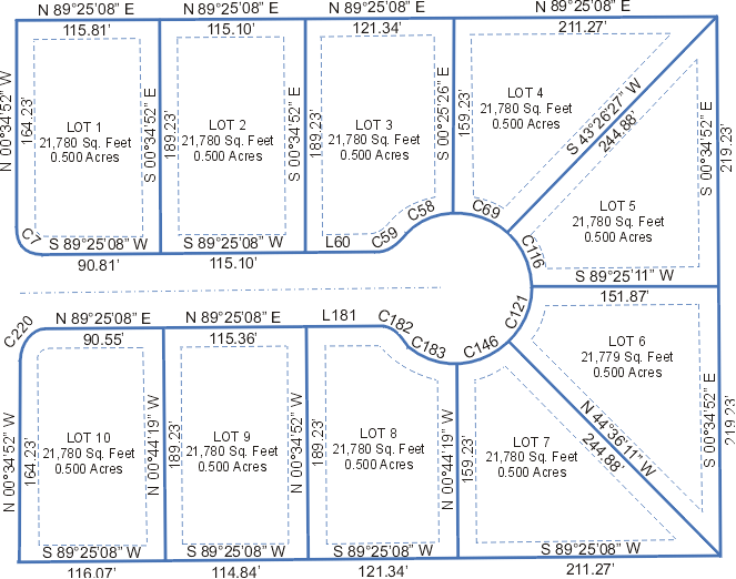
Automatically divide a parcel based on desired lot acreage, or divide it into equal parts based on the number of lots that your layout needs.
Quickly lay out the conceptual site design, or keep going and complete the final plat!
Add setback lines, easements, roads, cul-de-sacs, parking spaces, lot numbers and lot dimensions.
Over 40 symbols are included for you to use, and you can also make your own custom symbols.
Street names and curve dimensions can be placed along curves, and bearings and distances can be automatically placed along lines.
Deed-Chek is Built-in!
Subdivide includes ALL of the features of Deed-Chek, including:
- Automatically draw lots from a deed or legal description.
- Automatically draw a parcel by section/township/range.
- Calculate area and closure.
- Adjust error with Compass Rule Adjustment
- Click here to see more Deed-Chek features.
|
- Automatically subdivide a parcel into smaller lots.
- Create streets, roads & cul-de-sacs
- Over 30 linetypes to choose from.
- Draw easements and setback lines.
- Enter GPS coordinates (latitude & longitude).
- Plot lots in Google Earth.
- Plot a location in Google Maps.
- Export linework to a shape file.
- Export drawing to AutoCAD® via a DXF file.
- Draw arrowheads and leaders.
- Draw text along a curve.
- Custom bearings and distances.
- Import images of aerials and scanned TOPO maps for background or tracing..
- Calculate lot coverage with the Site Calculator.
- Calculate area for each lot.
- Force lots to be an exact area.
- Print entire drawing, or a single lot.
- Print rotated drawing for a better fit.
- Print layout to scale (any scale!)
- Automatically create parking spaces.
- Automatically create a legal description for a lot.
- Manage drawing items with layers.
Free Drawing Viewer and Plotter
Have your clients install the free drawing viewer and then they can view and plot the site plans that you send to them. (This free utility will allow drawings to be viewed and plotted but they cannot be modified).
|